Inwood
From Science and Technology: Baruch IDC 3002H
Inwood Hill Park
By: Alice Fong, Annie Chen, Arthur Ferker, and Duke Lee
Contents |
Introduction
| Location |
Address |
Dyckman Street |
|---|---|---|
| History |
First Settlement |
17th century |
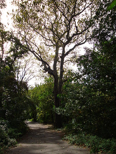
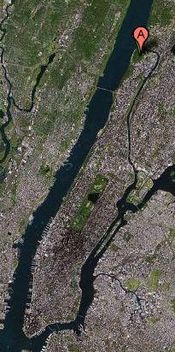
Inwood Hill Park is located in the northwestern corner of Manhattan Island. It is generally sheltered from the urban environment. Inwood Hill Park has varied geological components and history of land use. The hilltops in Inwood provide a view of the Hudson Valley, across Northern Manhattan, and parts of The Bronx. It is suggested that when Henry Hudson traveled up the Hudson River in 1609, he identified Inwood's hills as "primeval." The park contains the last primordial forest and salt-marsh of Manhattan.
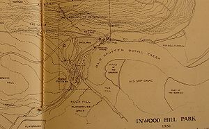
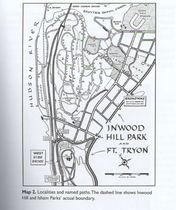
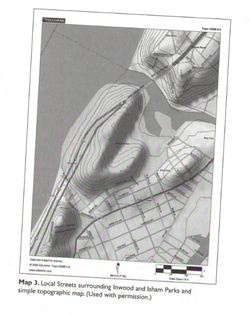
Inwood Hill Park is bound by Dyckman Street on the south, the Harlem River ont he north, and the Hudson River along its western edge.
History
Inwood Hill Park is one of the most natural areas left in New York City. It contains mass amounts of biodiversity for its size. The 196-acre park is comprised of a forest accompanied by archaeological relics, recreational fields, study areas, as well as jogging and pedestrian paths. The park was officially opened on May 8, 1926 after the city purchased surrounding areas of land starting in 1915 and continuing until the early 1940’s, which made the park what it is today. Some of the oldest trees that exist in Manhattan today are the tulip trees of Inwood. Also, Inwood contains a Copper Beech that is not native to the park and has been dated to at least 140 years ago. Other trees found throughout the park are Dogwood, Oak, Gingko, and Hickory.Inwood’s history and that of the nearby area dates back to when New York City was still owned by the Indians. After the Wiechquaesgeck Indians left the park they left behind mass amounts of archaeological artifacts which were later found in digs done by private and city archaeologists. Some of these finds include pottery shards, weapons, skeletons, and shell and bone implements. The many natural rock formations found throughout the park formed caves which were used by the Indians for shelter. Indians actually inhabited Inwood till as late as the 1920’s and 1930’s. A Native American store and museum in the park was operated by Princess Naomi, a member of the Algonquin-speaking peoples. Also, there was an Indian Life Reservation employed by Native Americans who gave tours of the caves, demonstrated native arts and crafts, and had a library containing books on American Indians. In Inwood there is also an area called Cold Spring Hollow where the local tribal groups of the Lenape Confederacy lived in caves and fished in the local waters. Shells as well as other artifacts that were uncovered there had been used by these early inhabitants who made the park their home. These people hunted deer, raccoons, and even bears for food. Their skins were used for everyday uses.
Legend says it that the Dutch purchased Manhattan from the Native Americans for $24 worth of trinkets. After they purchased the land, colonists from Europe settled and farmed on the land in the 17th and 18th centuries. And when the American Revolution came around, the Americans built a five-sided fort, which was known as Fort Cox, on the northwestern corner of the park. However, the fort was taken over by the British and Hessian forces in November 1776 until the end of the war in 1783. Luckily, most of the park remained untouched by the war and developments and a lot of artifacts were still able to be found because of this. In the 1800’s, country homes and philanthropic institutions were present throughout most of the park. Then it was finally bought by the New York City Department Parks & Recreation in 1916. It is still unknown how Inwood Hill Park got its name. The closest guess that people can think of is that this name could be a variant of the Native American name for a part of the park, Shorakapok.
In the early 1900’s, archaeological digs in the area uncovered two Native American burial sites. The remains were located near 203rd Street and Seaman Avenue. One of these sites contained the remains of an Indian woman and an infant and the other one contained remnants of a chief and his wife. Aside from these digs numerous other archaeological digs were also conducted within Inwood during the Indian, Colonial, and Revolutionary periods carried out by Reginald Pelham Bolton and William Calver. Even today there are faint remains of huts and oven pits, on the Payson Street side of the park, that were used by the Royalist forces during the occupation of the area.
Shorakapok: Interdependence
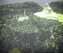
Shorakapok, called by the Native Americans, was a large campsite nestled up against Spuyten Duyvil Creek and beneath Inwood Hill. For the Lenape (Delaware Indians) of Mannahatta, this area of uptown was their “downtown”—northern Manhattan, as shown in the reconstructed view on the right. Shorakapok was the hub of human activity on the island; it provided everything the Lenape looked for: plentiful fresh water, easy access to the estuary for fishing, protection from the winter winds, and flat land to grow crops.
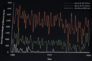
Native Americans that once resided in Inwood had discovered efficient ways to harvest agricultures. Modern crop models once again validate the ancient knowledge that beans, corn, and squash grow better together. Planted together in mounds, the three sister crops always depended on each other: beans fix nitrogen into the soil to feed the corn, the corn provides a platform for the beans to reach the sun, and the squash shades the ground with large leaves that hold in the water and keep weeds in check. The plot below is generated from a computer model which shows the dramatic effect of how natural fertilization from nitrogen-fixing beans can boost the magnitude and security of the corn harvest.
Down the Hudson or Harlem Rivers to the Harlem Plains and southern Manhattan, geological evidences showed that the camps of wigwams and likely longhouses were located along Seaman Avenue and along the Harlem River, near the site of today’s subway train depot. Oyster reefs were also present which contributed to a very rich marine habitat at the point where the two rivers split. Therefore, the Lenape depended on the natural world that surrounded them and in turn were participants in natural cycle of interdependence. Over the years, Lenape’s culture created a mosaic of habitat type of forests; many other species, especially plants and birds of open country, depended on these different habitats. The picture to the right shows an established Lenape village with plumes of smoke rising from campfires.
Inwood Today
On September 15, 1995, the Inwood Hill Nature Center was dedicated and opened to the public. It is located near the park entrance on 218th Street and Indian Road. Also, interestingly enough the center is located on Manhattan’s one and only salt-water marsh. The Nature Center has also been selected to be an interactive exhibit with constant monitoring of the natural area. It is the focal point of watching over eagles which have been placed in the park in order to be freed once they are able to adjust to the environment. Today Inwood is an unspoiled woodland refuge for nature lovers and as well as the public as a whole. The various trails throughout the park provide stunning views of the Hudson River and the Harlem River Ship Canal. In addition, the park is home to numerous birds and animals that can be appreciated in their natural habitats, some of which include raccoons, White-Footed Mice, Eastern Screech-Owls, and many more.
Role of Inwood
Inwood Hill Park today is important in New York City society, especially to the residents in the Inwood area. This park contains caves that were used by the Lenape before Europeans arrived, and the last salt marsh in Manhattan. Birdwatchers come to the park to see waterbirds, raptors, and a wide variety of migratory birds. The wooded section features the last natural forest standing in Manhattan. Inwood Hill Park includes baseball fields that are heavily used by local leagues. Tennis courts, playgrounds, a waterfront promenade and extensive hiking trails are also prominent components of the park. The park also includes a nature center and hosts many events organized by the Parks Department.
Story of Inwood
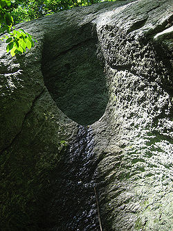
New York City residents and especially nature lovers would be surprised at how many interesting things they can find in this park. Marble, schist, and limestone for example, are prevalent in the area. Also, there is evidence of glacial striations and glacial potholes in the park. A glacier, about one quarter mile high, created potholes formed by swirling water streams with the help of gravel and rocks that drilled holes over thousands of years. Beaches are also no stranger to Inwood Park. Today there is only one small beach located next to the railroad trestle at the junction of the Hudson River and the Harlem River Ship Canal.
Land Use
Shells of the Common Oyster (Crassostrea virginica) left behind by Native Americans are signs on the inhabitants on the area, 1500 carbon-14 years B.P. With the establishment of New Amsterdam in 1624, Dutch colonial farmers displaced the Native Americans. They each owned orchards, marshland, and forests for woodlots.
Wolves were exterminated in 1686.
In 1900, the Broadway trolley line was laid through Inwood to Kingsbridge. In 1905, the IRT subway reached Dyckman Street and later Van Cortlandt Park at 242nd Street. The easy transportation to the city brought in large number of people to live in new apartment houses. Sherman Creek wetlands were filled in to create new land for buildings.
Ecology
During the American Revolution in the last half of the 18th century, colonial agriculture clearance practices severely eradicated the pre-Columbian forest of Inwood Hill Park, Manhattan, New York. Estates established after 1850’s introduced a new generation of invasive species, while native species planted in early estates branched out and eventually formed the Inwood’s forest. From 1930 to 1985, however, poor park management practices caused the reduction of forest coverage, an increasing area of wetlands, and it also caused the number of invasive shrub and vine species to nearly triple in such a short period of time.Trees and Plants in 1609
According to the Mannahatta project’s website, these are the trees and plants that have most likely would’ve lived in Inwood Hill Park. These include the Virginia Threeseed Mercury, Red Maple, American Hornbeam, Starved Panicgrass, Intermediate Woodfern, Prairie Fleabane, and White Wood Aster. More tree and plant types can be found on this link: http://themannahattaproject.org/m-about-this-block.php?bid=1847&fs=false&atb=0&atbsub=5
Soil Conditions
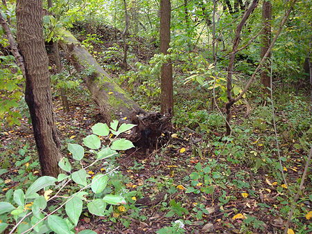
The park consists of a distribution of forest, successional field, salt marsh, and lawn communities. Forest vegetation in Inwood is divided into four types: valley, slope, north-facing, and successional fields. Since the 1940's, six salt marshes have grown, which are dominated by Spartina alterniflora (Saltmarsh Cordgrass) and Iva frutescens (Jesuit's bark). According to Robert E. Loeb, the author of Plant Communities of Inwood Hill Park, his soil analysis showed that "natural soils in Inwood are acid while fill soil pH is near neutral. Both types of soils are very low in potassium, nitrates, and phosphorus. Loeb's studies also indicated that non-native ground cover species are high in density, and the soil nutrient values in these species have been increasing over the years. These results provided evidence that cultivation existed in Inwood's successional field community.
Invasive Species
Inwood Hill Park can be generally divided into three forest sites: East ridge & slopes, East & West ridgetops, and West ridge & slopes. According to Robert E. Loeb, Prunus serotina Ehrh (Black Cherry), Sassafras albidum (Sassafras) and Viburnum acerifolium (Mapleleaf) have continued to form stands in Inwood’s East ridge & slopes forest. In 2003, Prunus serotina (Black Cherry) occurred at its highest density in the repeatedly disturbed fields of the West ridge & slopes forest area. Alliaria petiolata (Garlic mustard), another invasive specie, was present only in the ridgetops forest in 1985 and has since become the dominant non-native herb species in all of the forest areas. Furthermore, Celastrus orbiculatus (Oriental bittersweet), an invasive shrub and vine specie, along with Lonicera japonica (Japanese honeysuckle), Lonicera maackii (Bush Honeysuckle), and Rosa multiflora (Multiflora Rose) have quickly become the dominants in the cleared areas of all ridgetops forest areas. As mentioned earlier, soil eroding into the salt marsh has caused the dominance of upland invasive species, while replacing invasive species with native species has had mixed success, according to Loeb, because of limited funding to maintain plantings a dry environment while treating poor soils with herbicides.
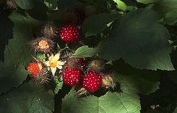
Wineberries
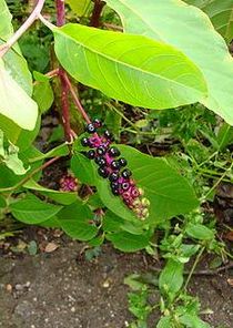
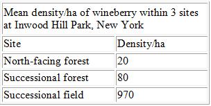
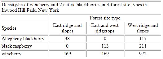
In Inwood Hill Park in southern New York, wineberry dominated the understory of yellow-poplar-white oak-northern red oak forest. They often occurred on sites with "deep soils" and with slopes greater than 10%. Wineberry occurred at various densities in 3 plant communities in Inwood Hill Park in southern New York:
Data from USDA Forest Service show that the north-facing forest area in Inwood is mainly dominated by chestnut oak, northern red oak, and yellow-poplar in the overstory and American witchhazel (Hamamelis virginiana) and northern spicebush (Lindera benzoin). Yellow-poplar, white oak, and northern red oak in the overstory took over the successional forest community while wineberry dominated the understory. In the successional fields, young mulberry (Morus spp.) and black cherry prevailed over the native periwinkles (Vinca minor), while poison ivy (Toxicodendron radicans), jewelweed (Impatiens capensis), and garlic mustard (Alliaria petiolata) prevailed over the underwoods.Furthermore, wineberry in Inwood is often associated with native blackberries including Allegheny blackberry (R. allegheniensis), black raspberry (R. occidentalis), sawtooth blackberry (R. argutus), and Pennsylvania blackberry (R. pennsylvanicus). Wineberry also coexists with other nonnative blackberries such as evergreen blackberry (R. laciniatus) and Himalayan blackberry (R. discolor).
Surprisingly, wineberry may occur at higher densities than its related species. For example, in Inwood Hill Park, wineberry was consistently recorded at higher densities than Allegheny blackberry or black raspberry where these species were found together.
In Inwood, populations of wineberry, as well as 14 other nonnative invasive species were said to be expanding as of 2008, and wineberry was described as one of the most "problematic species."
Deforestation
In recent years many trees throughout Inwood have been cut down or damaged so much that the trees suffer a slow death. Employees of the Parks department discovered 17 destroyed trees in weeks of March 2009 and before. Some of these destroyed trees included pines, sugar maples and hackberries, as well as two young tulip trees, which were left to rot after they were chopped down. Often times these trees are cut down by people to improve the views from their apartments. But what is even worse are the attacks on the trees that are for no apparent reason other than destroying them. In March of 2008, 35 eastern red cedars were destroyed selectively, their stumps left sitting amongst trees of other species in the same area that were not even touched. Two years before that in November, 28 cedars were also killed in another part of the park. This destruction of trees is unnecessary and harmful to both the trees and any animals that use them for shelter.
Mammal Trapping and Findings
Inwood Hill Park is home to numerous birds and animals that can be appreciated in their natural habitats, some of which include raccoons, White-Footed Mice, Eastern Screech-Owls, and many more.
On October 9th, our group along with two of our professor’s graduate students, Steven and Paolo, conducted a population research experiment on white-footed mice (Peromyscus leucopus) in Inwood. The experiment was conducted over four days and three nights.
Methods for Setting Traps
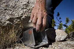
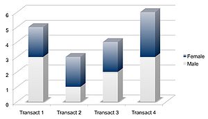
• We divided the park into four transects and set up 49 traps (7x7) in each area.
• Each row of seven traps was placed in a straight line perpendicular to the main path and each transect was about fifteen steps apart from each other.
• To mark the places of the traps we used flags, color coated by transect and numbered from one to seven for each individual row.
• Once placed, a small amount of grains and seeds were inserted in every trap along with a piece of cotton intended to simulate the mouse’s nest and provide warmth during the night.
• The traps were allowed to rest over night and were inspected during the next morning.
Methods for Studying Mice
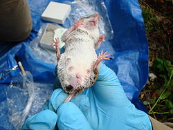
• Once a mouse was found in a trap it was brought back to the “working area”.
• Each mouse was then inspected for sex, pregnancy, botflies, and afterwards weighed.
• After all the information was written down a small piece of the mouse’s tail was cut off for record keeping as well as DNA sampling.
• Following the examination the mouse would then be released back into the forest, at the point where it was captured.
Results
• We found exactly 9 males and 9 females, which indicates an even distribution of sex among the mice population in Inwood.
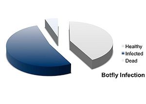
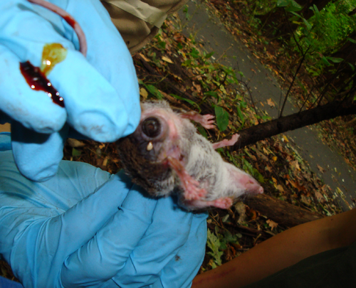
• Botfly larva, which belongs to a family of Oestroidea, seems to be the most common parasite among the white-footed mice population in Inwood: out of 18 white-footed mice we found, 10 contain botfly larvae; the larvae were removed successfully.
Botfly Parasitism
Bot flies are common parasites of the Peromyscus Leucopus, or more commonly known as the white-footed mouse. The Macaulay students at Baruch College (who also produced this wiki page), led by their Professor, Jason Munshi-South, have traveled to Inwood Hill Park to investigate the extent of infections that bot flies can make on the white-footed mouse. A similar study was done by Professor Michael J. Cramer and Guy N. Cameron at the University of Cincinnati whose goal was to investigate the effects of the parasites on the mice and also how long these mice survive. The parasitism on the white-footed mice was measured by the rate in which the parasitism occurred, the number of parasites on each infected mouse, and how scattered the parasites were on each mouse (clumped or random). The study also searched for spatial and temporal patterns. After analyzing the relationship between the mice and the parasites, it was found that the infected mice were able to live longer on the trapping grids than uninfected ones. Overall, it was found that the infections were clumped on these mice but when looking at simultaneous infections, it was found that the parasites were randomly distributed. Most of the white-footed mice had single infections; however, re-infections were not rare at all. This led to bimodal patterns of parasitism. The rate of occurrence was not at all correlated with the density, sex ratio, or proportion reproductive. However, there was a major relationship between the number of parasites on each infected mouse and density and sex ratio. All these results show that bot flies are random on their hosts, in this case the white-footed mouse, and also that the hosts show tolerance up to a level for the bot fly parasitism. In conclusion, bot fly does not seem to have a drastic influence on the white-footed mouse, and it does not have a threatening effect on the ecology of Inwood Hill Park.
Geology
In terms of its geology, Inwood is rather interesting. The park happens to be located between several earthquake faults: the Hudson River, Dyckman Street, Spuyten Duyvil, and the Harlem River. Since about a million years ago glaciers covered the entire New York metropolitan area, there is still evidence of glacial grooves and glacial potholes within the park. These groves and potholes were formed by a glacier, which when melting and receding, created swirling water streams that carried gravel and rocks that drilled holes over a period of thousands of years. Beaches were another relatively common part of Inwood, though today there is only one small beach located next to the railroad trestle at the junction of the Hudson River and the Harlem River Ship Canal. Between the 1890’s and the 1930’s, the Spuyten Duyvil Creek, which doubled as a beach, was transformed into the Harlem River Ship Canal with the help of funds raised by the government.
The oldest bedrock unit is the Fordham Gneiss, which is overlain by the Inwood Marble. The Inwood is overlain by various schistose rocks collectively designated as the Manhattan Schist.
Fordham Gneiss. The Fordham Gneiss constitutes the oldest underpinning of rock formations in the NYC area. It contains Proterozoic ortho- and paragneiss, granitoid rocks, metavolcanic- and metasedimentary rocks.
Inwood Marble. The Inwood consists of Paleozoic calcitic and dolomitic marble. The Inwood Marble underlies the Inwood section of northern Manhattan, the Harlem lowland Northeast of Central Park, occurs as thin belts in the East River channel and in the subsurface of southeastern Manhattan, and also crops out in The Bronx and Westchester County.
Manhattan Schist. The Manhattan Schist consists of Paleozoic massive rusty- to sometimes maroon-weathering, medium- to coarse-textured, biotite-muscovite-plagioclase-quartz-garnet-kyanite-sillimanite gneiss.
All three bedrock units (Fordham, Inwood, and Manhattan) are exposed in the vicinity of Inwood park.
Topography
Inwood's topography consists mainly of marble and schist, two metamorphic rock types which dominate Inwood Hill.
The ridge top of Inwood Hill Park still retains its topographic configuration, but the shapes of the surrounding landfill have been altered by landfills that raise the surface. The ball fields and Gaelic Field on the east side of the park were created with landfill from the IND subway construction in the 1930s.
Glacial Activity
Even though today Inwood is the only place with a natural forest and salt marsh found in Manhattan, the land actually once lay beneath an enormous sheet of slow moving ice. The last ice age began about 1.5 million years ago and lasted all the way until around 10,000 years ago. During the beginning of the Pleistocene period global temperatures dropped drastically and huge masses of snow and ice formed in and around the Arctic. These large masses of snow sometimes were even as thick as two miles. The massive weight of the ice sheet caused great pressure towards the bottom causing the snow underneath to solidify, in turn creating a surface on which glaciers could travel on. Most of the changes in Manhattan and especially Inwood were actually created by the Wisconsin ice sheet.
The Wisconsin ice sheet started moving south from the Arctic around 100,000 years ago. It reached the area which is now New York approximately 50,000 years later. Around this time, the Wisconsin ice sheet had already lost some of its size, though it was still an astonishing 300 feet thick and extended all the way from Massachusetts to Montana. As the glacier moved throughout this region it deepened the Hudson River bed, as well as carved out geologic features such as the Great Lakes and the Finger Lakes basins, and left remnants on the Adirondack Mountains. This glacier also dumped heaps of gravel and pebbles even moving whole boulders from the Palisades to Central Park. During the glacier’s movement top soil was turned over, the land was leveled, and depressed areas were filled with glacial till. It was this glacial activity that formed the terrain of Inwood with its many caves, valleys, and ridges.
References
1. Loeb, Robert E. “The Ecological History of an Urban Park The Ecological History of an Urban Park.” Journal of Forest History Vol. 33, No. 3 (1989): 134-143. Print. Gives a detailed description of the ecology in Inwood Park
2. Paumgarten, Nick. “The Mannahatta Project; What did New York look like before we arrived?” The New Yorker: Our Local Correspondents Vol. 83 No. 29 (2007): 44. Print.
Compares Inwood’s geology and ecology during the colonial era to modern days
3. Fitzgerald, Judith M. “Historical ecology of Inwood Hill Park, Manhattan, New York.” The Journal of the Torrey Botanical Society (2008): 135(2):281-293.
Describes the evolution of species in Inwood Park from the colonial era to today
4. Dwyer, Jim. “In a City Park, a Crime Against Nature.” The New York Times. 22 March 2008. Web. 24 September 2009.
Depicts how deforestation and other harmful human activities are destroying parks like Inwood
5. Fahim, Kareem. "Another Assault on the Trees in an Upper Manhattan Park." The New York Times (2009): A35.
Talks about destruction of trees throughout Inwood Hill Park in last few years
6. Renner, James. "Article Index: Inwood Hill Park." September 2003. Washington Heights & Inwood Online. 21 September 2009
Describes the history of Inwood Hill Park
7. Merguerian, Charles, 1996c, Stratigraphy, structural geology, and ductile- and brittle faults of New York City, p. 53-77 in Benimoff, A. I. and Ohan A. A., chm., The Geology of New York City and Vicinity, Field guide and Proceedings, New York State Geological Association, 68th Annual Meeting, Staten Island, NY, 178 p.
Describes the different types of bedrock in New York and goes on to discuss the bedrock in and around Inwood specifically
8. Fitzgerald, Judith M. "The ecology, geology, and history of Inwood Hill Park in northern Manhattan, New York County, New York." Dissertation Abstracts International. 67.11 (2006): 323. Print.
Describes Inwood's geological make-up
9. Loeb, Robert E. "Plant Communities of Inwood Hill Park, New York County, New York." Bulletin of the Torrey Botanical Club. 113.1 (1986): 46-52. Print.
Describes the different plants and plant groups in Inwood
10. Lovett, Gary M. "Atmospheric Deposition to Oak Forests along an Urban−Rural Gradient." ACS Publications. Environ. Sci. Technol. 34 (20) (2000):4294–4300
Patterns of atmospheric deposition in Inwood
11. Anderson, M. O. 1994. Woodlands, Wetlands, & Wildlife: A Guide to the Natural Areas of New York City Park. New York, NY City of New York Department of Parks and Recreation and the City Parks Foundation. 84.
12. Bolton, R. P. 1932. Inwood Hill Park on the Island of Manhattan. New York, NY Dyckman Institute. 29.
13. Bolton, R. P. 1924. Washington Heights Manhattan, Its Eventful Past. New York, NY Dyckman Institute. 283.
14. Small, J. K. 1937. The jungles of Manhattan Island 2, Inwood Hill Park. J. New York Bot. Gard 38:208–216.
15. Horenstein, Sidney. Inwood Hill and Isham Parks: Geology, Geography and History. Natural History of New York City. X. New York City: The Linnaean Society of New York, 2007. Print.
16. Sanderson, Eric W. Mannahatta: A Natural History of New York City. New York: Abrams, 2009. Print.
17. Cramer, Michael J. Effects of Bot Fly Parasitism on a Population of White-footed Mice. Journal of Mammalogy. Vol. 87(6):1103-1111 (2006): 10.1644/05-MAMM-A-388R1.1
